How to
Get There
Get There
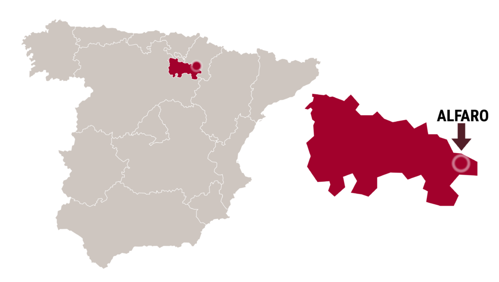
Location
Alfaro is located at the eastern edge of La Rioja, near the border with Navarra and Aragón. Its municipal area stretches from the Ebro River groves to Monte Yerga, which, at 1,101 meters, is the highest point in the municipality.
Alfaro is approximately 70 km from Logroño, 90 km from Pamplona, 90 km from Soria, and 100 km from Zaragoza.
Transport Connections
Due to its strategic location, Alfaro is very well connected by road.
The N-232 directly connects it with Calahorra, Logroño, Zaragoza, and other cities in the Ebro Valley.
The AP-68 (Vasco-Aragonese Motorway) links it with Bilbao, Zaragoza, and the Mediterranean corridor.
The L-692 and LR-6801 connect Alfaro with nearby towns such as Corella, Castejón, and Grávalos.
| TAXI | ||
| Parada en C/ Losada, nº 2 (junto al Casino) | ||
| Company | Address | Phone |
|---|---|---|
| José Aznar Bayo | C/ Trasmuro, 16 | 941180951 |
| Buses | |||
| Bus Station located at Ctra. de Zaragoza, nº 2 | |||
| Company | Route | Web | Phone |
|---|---|---|---|
| Autobuses Jiménez | Burgos – Logroño – Zaragoza | jimenezmovilidad.es | 941 202 777 |
| Autobuses Jiménez | Alfaro-Cornago-Valdeperillo | jimenezmovilidad.es | 941 202 777 |
| Autobuses Alsa | Pamplona-Fitero-Soria | alsa.es | 917 542 004 |
| Railway | |||
| Train station located at Avda. de la Vía, s/n | |||
| Company | Route | Web | Phone |
|---|---|---|---|
| RENFE | Bilbao – Logroño – Zaragoza | www.renfe.es | 912 320 320 |
| Airports | ||
Due to its location, the nearest airports are: For flight information, you can visit: www.aena.es | ||